If you’ve ever watched a drone reel and thought — “I wish I could shoot something like this” — Dehradun is secretly one of the best places in North India to make that dream real.
Nestled between the Shivalik Hills and the Doon Valley, this city offers a rare mix of mountains, rivers, lush forests, colonial architecture, and ancient temples — all within a short drive from each other. For a drone photographer, that’s basically a jackpot.
But knowing where to fly is just the beginning. You also need to know about permissions, safety, best times, and what kind of shots you can realistically capture. So in this guide, I’m covering everything — from the most cinematic aerial spots to the practical stuff that most blogs skip.
Let’s get into it.
Why Dehradun is a Dream for Drone Photographers
Before we list the spots, let me tell you why Dehradun deserves a place on every aerial photographer’s radar.
First, the landscape variety is unreal. You can shoot a misty river gorge in the morning, then fly over a centuries-old monastery by afternoon, and end the day with golden-hour shots over forested hills. Not many cities in India offer this kind of visual range within a 30-km radius.
Second, the city is still relatively uncrowded compared to places like Manali or Nainital, which means you often get cleaner shots without crowds photobombing your frame.
And third — the light here is genuinely spectacular, especially in the pre-monsoon and post-monsoon months when the air is crisp and the Himalayas are visible on clear days.
Now, let’s talk spots.
10 Best Drone Photography Spots in Dehradun
1. Robber’s Cave (Guchhupani) — The Natural Gorge Shot
If you want a shot that instantly says “this is something different,” Robber’s Cave is where you start. The natural limestone gorge with a river flowing right through it creates one of those rare top-down aerial perspectives that genuinely stops people mid-scroll.
The best drone shot here is captured early morning — around 6:30 to 7:30 AM — when the gorge fills with soft diffused light and there are barely any tourists. Fly low and slow through the corridor for a dramatic tracking shot, or go high for a bird’s-eye view of the canyon.
Location: Anarwala Village, about 8 km from Dehradun city center
Best Time to Shoot: Early morning, October to February
Drone Tip: Wind funnels through the gorge — fly cautiously and keep manual control ready
Planning to visit? Check out the top places to visit in Dehradun for a full itinerary.
2. Sahastradhara — Sulphur Springs & Terraced Waterfalls
Sahastradhara, which literally translates to “Thousandfold Spring,” is one of Dehradun’s most scenic natural sites. From the air, the terraced landscape, winding road, and the sparkling springs look completely different from what you’d see at ground level.
The aerial view here is best captured during or just after the monsoon (September–October) when the waterfalls are at full flow and the surrounding hills are intensely green. Try a slow reveal shot — start tight on the falls, then pull back to show the valley.
Location: Sahastradhara Road, 14 km from city center
Best Time to Shoot: September to November (post-monsoon greenery)
Drone Tip: The area gets crowded on weekends — shoot on a weekday morning
3. Forest Research Institute (FRI) — Colonial Architecture from Above
FRI is one of those places that absolutely transforms from an aerial perspective. The grand colonial-era building, surrounded by 450 hectares of manicured lawns and forests, is stunning from the ground — but from 100 meters up, it looks like something out of a Harry Potter film.
The symmetry of the building’s architecture, the green expanse around it, and the Shivalik Hills framing the background combine for one of the most refined drone shots in Dehradun.
Location: FRI Campus, Chakrata Road
Best Time to Shoot: Early morning, March to May
Permissions Note: FRI is a government campus. You’ll need prior written permission from the FRI Director’s office before flying. Don’t try to sneak a flight here — security is present and strict.
Read more about this iconic spot in our Dehradun travel guide.
4. Mindrolling Monastery — The Great Stupa from the Sky
At 220 feet, the Great Stupa at Mindrolling Monastery is one of the largest Buddhist stupas in Asia. From the ground, you can appreciate its size. From the air, you can see its perfectly circular design, the surrounding monastery complex, and the Japanese gardens — all of which paint an absolutely breathtaking picture.
This is one of the most culturally rich drone shots you can get in Dehradun. Early morning golden hour here is magical — the white stupa catches the first light in a way that makes the whole frame glow.
Location: Clement Town, southern Dehradun
Best Time to Shoot: 6 AM to 8 AM for golden hour
Permissions Note: This is an active religious site. Always approach the monastery management for permission before flying. Respect the space — no flying during prayer hours.
5. Rajaji National Park — Wildlife & Wilderness Aerials
For drone photographers who love raw, untouched wilderness, Rajaji National Park is the spot. Spanning 820 sq km across Dehradun, Haridwar, and Pauri Garhwal districts, the aerial views of the sal forest canopy, river corridors, and valley overlooks are stunning.
That said, this is also the most restricted spot on this list. Flying drones over a national park requires permission from the park authority and the Wildlife Crime Control Bureau. Don’t fly without it — and don’t fly near wildlife.
Location: Haridwar Road, about 20 km from Dehradun
Best Time to Shoot: November to March (dry season, clearer views)
Permissions Note: Mandatory permission from Rajaji Tiger Reserve administration required. Apply in advance.
6. Mussoorie Road — The Hairpin Bends Shot
You’ve seen this kind of shot in travel documentaries — a winding mountain road snaking up through dense forest, with a tiny vehicle crawling around a hairpin bend. The Dehradun to Mussoorie road (NH-707A) offers exactly this, and it’s one of the most cinematic drone sequences you can capture from this region.
The best spot to fly is near the Gandhi Chowk to Library Chowk stretch or near the Zig Zag turns approaching Mussoorie. On a clear day, you’ll also get the Doon Valley stretched out below as a backdrop.
Location: Mussoorie Road / NH-707A, starting from Dehradun
Best Time to Shoot: Early morning in winter (October to February) for mist-free shots
Drone Tip: Traffic can be dense — early morning weekday flights give the cleanest road shots
7. Lachhiwala — Forest & Stream Aerials
Lachhiwala is primarily known as a picnic spot, but from the air, it reveals a beautiful patchwork of sal forest, the natural stream, and the man-made pool — all surrounded by dense green canopy. It’s quieter than the more touristy spots, which makes it easier to fly without drawing too much attention.
The aerial shot here works especially well in the post-monsoon season when the stream is flowing well and the forest is at peak green. A wide-angle shot from 80-120 meters shows the contrast between the natural stream and the forest clearing.
Location: Doiwala Road, about 22 km from Dehradun
Best Time to Shoot: September to November
8. Tapkeshwar Temple — Riverside Cave Temple
This ancient cave temple dedicated to Lord Shiva sits right on the banks of the Suswa River. From the air, the combination of the riverbed, the cave temple structure, and the surrounding hills creates a deeply atmospheric shot — especially in the early morning when pilgrims are arriving and the light is soft.
It’s not the most dramatic aerial location, but for photographers who value a cultural-spiritual story in their frames, this is a unique one.
Location: Garhi Cantt, about 7 km from clock tower
Best Time to Shoot: 6 AM to 7:30 AM, winter months
Drone Tip: Be mindful of worshippers — don’t fly directly over the temple. Shoot from an angle that captures the river and surrounding landscape with the temple as a contextual element.
9. Dehradun Clock Tower (Ghanta Ghar) — Urban Aerial Story
Drone photography isn’t just about nature. The Clock Tower area — the heart of old Dehradun — tells a completely different kind of story from the air. The bustling market streets, the old colonial architecture, and the radial road pattern around the tower make for a visually rich urban aerial.
This is also one of the trickier spots logistically — it’s a busy urban area and flying here requires proper permissions and careful flight planning. But if you get the shot, it’s a striking contrast to the natural landscapes that Dehradun is better known for.
Location: Rajpur Road, central Dehradun
Best Time to Shoot: Early morning (6 AM to 7:30 AM) before the market opens
Permissions Note: Urban airspace — ensure your flight plan is compliant with DGCA regulations.
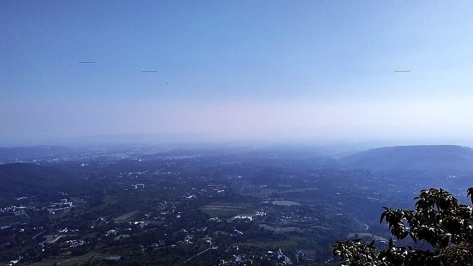
10. Doon Valley Viewpoints (Mussoorie Side) — The Classic Panorama
And finally — if you want the iconic Dehradun aerial, this is it. From the ridge near Mussoorie (Gun Hill area, Lal Tibba surrounds), you can capture the entire Doon Valley spread out below — Dehradun city, the patchwork of fields and forests, the Ganga canal glinting in the distance, and on a clear day, the Himalayan peaks beyond.
This is arguably the most dramatic drone shot in the entire region. A slow pullback from the edge of the ridge to reveal the full valley panorama is the kind of clip that gets shared.
Location: Mussoorie ridge area (~35 km from Dehradun)
Best Time to Shoot: October to February, early morning before haze builds
Drone Tip: Wind is strong and gusty on the ridge — fly conservatively and keep return-to-home set
DGCA Rules & Permissions — What You Must Know Before Flying
This section is non-negotiable. If you’re flying a drone in India without following DGCA guidelines, you’re not just risking a fine — you could get your equipment confiscated.
Here’s the quick summary of what you need to know:
Register Your Drone: All drones above 250 grams must be registered on the Digital Sky Platform run by DGCA India. This is mandatory — no exceptions.
Get a Remote Pilot Certificate (RPC): If you’re flying a Small category drone (250g to 25 kg), you need an RPC. You can apply through the Digital Sky Platform.
File a Flight Plan: Before flying in controlled or restricted airspace (which includes areas near airports, government buildings, and national parks), you need to file a flight plan and get approval.
Green, Yellow & Red Zones: India’s airspace is divided into green (fly freely), yellow (needs permission), and red (no-fly) zones. Dehradun itself has yellow zone areas — always check the Digital Sky map before you fly.
No-Fly List for Dehradun specifically includes:
- Within 5 km of Jolly Grant Airport
- Over Rajaji National Park without permission
- Over government and military installations
- Over crowds or public gatherings
Best Time of Year for Drone Photography in Dehradun
The season you fly in dramatically affects what your shots look like.
October to February is the best overall window. The air is clear, visibility is excellent, the Himalayas are often visible, and the light is beautiful. Temperatures are cool but flyable.
March to May is also good — the landscape is lush before the heat peaks, and flower blooms add color to your shots. Pre-summer haze can build up by afternoon, so stick to morning flights.
June to September (Monsoon) is the trickiest. You get incredible green landscapes and powerful waterfalls, but rain and low clouds can ground you for days at a time. If you do fly, do it on clear mornings right after a rain — the freshly washed air gives stunning clarity.
Gear Recommendations for Dehradun Drone Photography
You don’t need to break the bank, but a few things make a big difference in mountain environments.
Drone: DJI Mini 4 Pro is a great option for travel — it’s under 249g (no registration required in many countries, though in India registration is now needed regardless), folds compact, and shoots 4K. For serious aerial work, the DJI Air 3 or DJI Mavic 3 Pro give you longer range and better camera performance.
ND Filters: Essential for smooth video in bright mountain light. An ND4/8/16 kit gives you flexibility across lighting conditions.
Extra Batteries: Mountain cold drains batteries faster than you’d expect. Carry at least 3 fully charged batteries.
Wind Awareness: Dehradun’s valley terrain creates unpredictable wind — especially near ridges and gorges. Never fly at rated max wind speed; give yourself a 30% margin.
Nearby Day Trip Options for Drone Photographers
While you’re in Dehradun with your drone, these nearby destinations are absolutely worth the drive.
Mussoorie (35 km): The ridge-line views and Mall Road aerial shots are iconic. Read our Dehradun to Mussoorie travel guide 2026 before you head up.
Rishikesh (43 km): The Laxman Jhula area and the Ganga from above are stunning — though airspace around the ghats can be restricted. Plan carefully.
Haridwar (54 km): Har Ki Pauri from the air during Ganga Aarti is one of those once-in-a-lifetime shots — but permissions are strict and the area is heavily restricted. Approach with advance planning.
Offbeat Treks: Some of the most dramatic aerial shots in the Dehradun region are found at the trailheads and ridges along offbeat trekking routes in Dehradun — many of which are uncrowded and unrestricted.
Where to Stay While Shooting in Dehradun
If you’re planning a multi-day drone photography trip, staying near Rajpur Road or the Mussoorie Road corridor gives you easy access to most shooting locations. The best mountain view cafes in Dehradun are also great spots to plan your shot list over a chai while watching the light change on the hills.
Quick Reference Table: Drone Spots at a Glance
| Location | Best Time | Permission Needed | Difficulty |
|---|---|---|---|
| Robber’s Cave | Oct–Feb, early morning | No (public area) | Easy |
| Sahastradhara | Sep–Nov | No (public area) | Easy |
| FRI Campus | Mar–May, morning | Yes (FRI Director) | Moderate |
| Mindrolling Monastery | Oct–Feb, golden hour | Yes (monastery) | Moderate |
| Rajaji National Park | Nov–Mar | Yes (park authority) | Hard |
| Mussoorie Road | Oct–Feb, early morning | No (public road) | Easy |
| Lachhiwala | Sep–Nov | No (public area) | Easy |
| Tapkeshwar Temple | Oct–Mar, morning | Recommended | Moderate |
| Clock Tower Area | Year-round, early morning | Yes (urban airspace) | Hard |
| Doon Valley Viewpoints | Oct–Feb, morning | No | Easy |
Final Thoughts
Dehradun doesn’t market itself as a drone photography destination — and honestly, that’s part of what makes it so good. The spots aren’t overrun, the landscapes are varied, and with a bit of planning around permissions and timing, you can come away with footage that genuinely stands out.
The one thing I’d say above all else: don’t rush the process. The best drone shots from Dehradun require patience — getting there before sunrise, waiting for the light to be right, scouting locations the day before. But when the moment comes together, it’s completely worth it.
If you’re planning your trip to Dehradun around drone photography, start with the complete Dehradun travel guide on Chalo Pahaad — it covers places, food, weather, and how to get there, all in one place.
Happy flying.
External Resources:
- DGCA Digital Sky Platform — Drone Registration & Flight Plan
- DGCA Drone Rules 2021 — Official Guidelines
- Rajaji Tiger Reserve — Official Site
Published on ChaloPahaad Dehradun Guide | Last updated: May 2026
Tags: drone photography, aerial photography, Dehradun, Uttarakhand, travel guide, photography spots